The Japanese sport of sawanobori “shower climbing” in Daisetsuzan National Park
“We have to climb that?” I asked, craning my neck to see the black, water-slick rock that stood between us and the next pool, part-way through our trip up the Teninkyo Gorge on Mount Tomoraushi in Hokkaido`s wilderness heart, Daisetsuzan National Park.
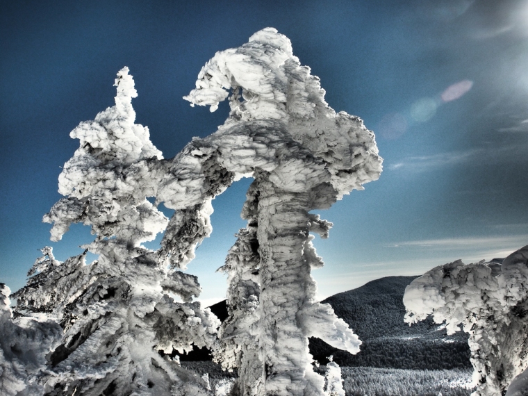
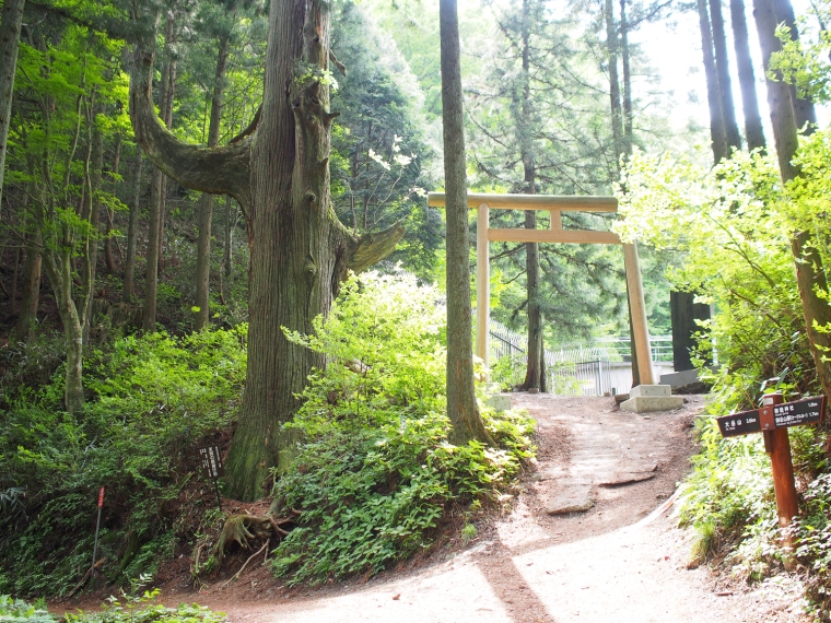
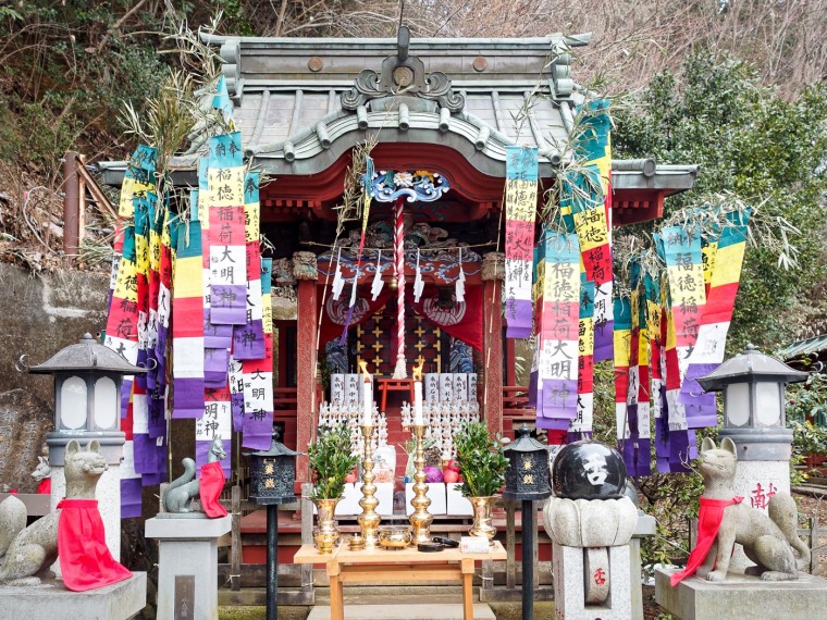
Water and high places hold special significance in Japan. From the very beginning, when Izanagi and Izanami – two lovesick gods at play in the early cosmos – reached down from the Floating Bridge with a heavenly spear and created the Japanese archipelago, the relation between high and low, base and superstructure, has defined the cycle of life on these volcanic islands. Even today in this hyper-tech nation, yamabushi, Shinto holy men, worship mountains as the soul of the nation. Meanwhile, back at sea level, floods and tsunamis plague farmers and fishermen, and typhoons sweep in from the East China Sea, bringing wrath-of-god like rain to the coasts. Fast flowing rivers and waterfalls vein the volcanic landscape.
Water and high places were also taking on a special significance for me as I stood waist-deep in a raging mountain stream, balanced on rocks as smooth and round as 100-year-old eggs. Ahead a waterfall rose out of a sumi-e ink painting. Water cascaded down toothy rock, into a pool the color of green tea. Earlier in the day, as dawn refused to light our cold, shadow-filled bivouac, and I pulled sodden shoes onto chilled feet, I had offered up a prayer to the mountain gods for deliverance from this boulder-strewn river, swollen with lashings of rain from the early autumn at higher altitude.
Apparently, my prayers were about to be answered.
Two days of hiking not on but in the Kuwaaunni River, and my introduction to sawanobori, the distinctly Japanese sport of mountain stream climbing, was not working out as planned.
Somewhere far above, in a snow-streaked meadow, a cabin promised warmth, comfort and safety on the shore of an alpine lake. Or so my companions, Martin and Hashi, assured me. All we had to do was get there.
Already, the late afternoon sun was dropping behind the gorge walls. Along the riverbank, ryukyu pine and sa-sa, bamboo grass, exuded the damp breath of early evening. River water surged around our waists. Once again, night threatened to catch us short of our destination. Along the narrow shore, the sa-sa would make a hardscrabble bivouac. Spray from the falls coated everything in a hypothermic mist. Being wet and cold is, it seems, a regular part of the wilderness sawanobori experience. So is running late.
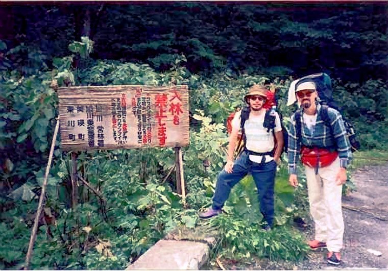
A sign at the blocked off trailhead warned that high water levels, rapids, rock falls and treacherous footing had killed several climbers over the last few years, and the route was closed until further notice. I know this because Martin translated the written kanji characters as we stepped over the single strand of chain and hiked up a boulder field, past gorge walls freshly wounded by falling rocks.
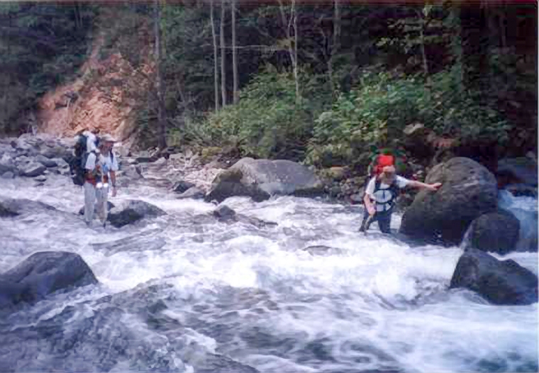
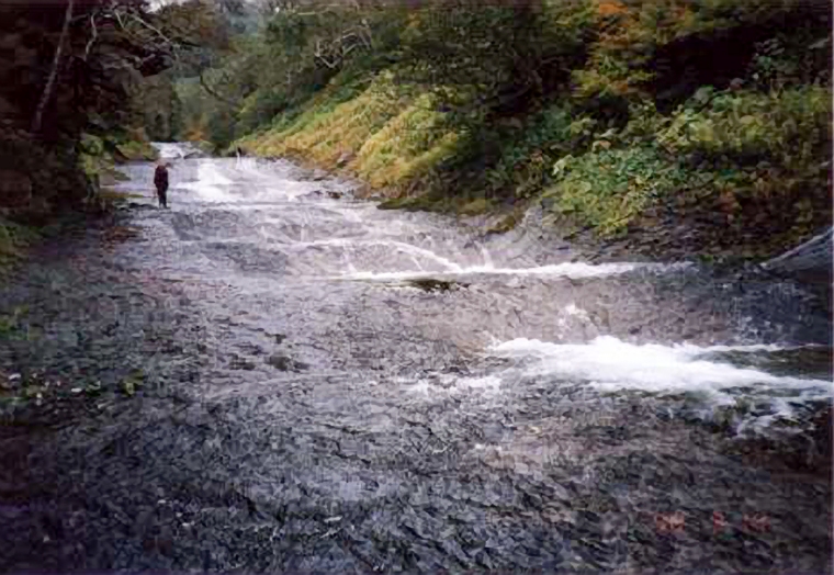
By morning, our special felt-soled shoes were frozen into blocks. Ice melted between chafed toes as we struck out into the main channel. The current had scooped out hollows in the river bed, and wooden hiking staffs gave much needed support as we navigated past hidden sinks and ankle-twisting rock jams. The gorge narrowed to less than the width of a Tokyo alley as we climbed higher on Tomoraushi’s slopes. Rock outcrops thrust into the treacherous main channel, and forced us to make improvised horizontal free-climbs. We boulder-hopped along the sa-sa and rubble-choked riverbank to dodge the worst of the rapids, and swung from shore to shore in a daze of constant immersion.
An ever-changing trail demands constant attention, and the familiar pain- and time-numbing rhythm of a good hiking pace eluded us. The water was cold, but the sun shone brightly into the gorge, quickly drying shirts and pants soaked by the occasional stumble in the fastest, deepest main channel of the stream as we switch-backed between close shores.
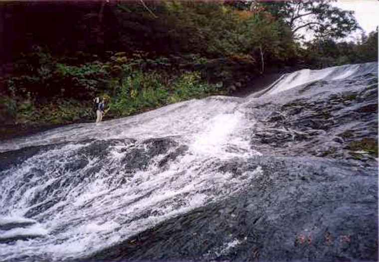
A sinuous rut uncurled up the loose, wet earth at the side of the waterfall, and required a scramble, limbs sprawled like a water bug, grasping at grass, roots, anything, to keep climbing. Water roared past our heads, and turned to smoke on the toothy rocks below. As would we, if we lost momentum and slipped off the rut. But we didn’t lose momentum, and the trail continued over the lip of the fall, onto rock as flat and smooth as inkstone, and covered in slick algae and a patina of fast-flowing, ankle-deep water. The gorge walls offered no place to pull out, no handholds to grasp, if someone slipped. We paused a moment, taking in the beauty of this natural garden, the green and tan rock, the green and blue water, the lush green, ruddy gorge walls.
“Kind of like walking on a water slide,” Martin concluded. “With nothing to catch if you fall.”
We continued up what turned out to be a sequence of short falls, a staircase of water-worn rock. A single strand of weathered laundry cord provided dubious protection on the most treacherous climbs. Other times there was only bamboo grass or roots to grab. Above us the gorge opened onto the broad-shouldered slopes of Tomoraushi, aglow with red and orange leaves in the early autumn of higher altitude.
For the next couple of hours we followed worn spots in the alpine meadow and hopped across boulders the size of Honda hatchbacks as we struck out for the main trail. On into the dusk. Below, the street and house lights of Asahikawa, the nearest city, spread out below and behind us, until low clouds and rain reduced everything to a dreary haze. Our headlamps picked out a trail as darkness settled and the wind continued to build.
Until, finally, even Martin had to admit we wouldn’t reach the hut that night. We pitched tent in a hollow in the meadow floor, partly protected from the wind by a jumble of boulders that was also home to a colony of pika.
Our tent made a blue lantern in the gray, miserable twilight that settled over the meadow. We cooked noodles and rice inside the tent, Japanese style, and turned our campsite into one big sushi roll for any passing bears.
To christen this campsite, as he had the previous night, Hashi used his own brand of bear deterrence: clusters of firecrackers tossed into the surrounding gloom. AThe chance of a bear encounter in this forsaken place seemed remote. Surely bears were smart enough, unlike us, to spend the night in the tree line, out of the worst of the weather? I tried to take comfort in this rationalization, and in the lingering aroma of gunpowder from the firecrackers, while Hashi took comfort in a deep, snoring sleep. A can of bear mace lay next to his head.
Cocooned in my sleeping bag, I speculated on our chances of survival if a bear did rip through our tent. The irony of being eaten by a grizzly in a country most people didn’t know even had bears, preyed on me as night thickened and the weather worsened.
“Hashi thinks it’s about 10 hours from here,” Martin reported at dawn. “It” was a rotenburo in the next valley; a spot where a second river that emerged from deep within Tomoraushi’s deeply buried volcanic heart pooled into a natural hot spring.
With the start of a new day we had also, it seemed, adopted a new motivation strategy for making trail time. Grim pragmatism would take the place of gentle humor and cajoling. Martin and Hashi had to be back to work the next morning. The thought of climbing down a trail as rough as the one we’d climbed up, in the dark, with only two dying head-lamps to navigate with, chilled as deep as the rain-soaked morning that awaited outside.
Dry hiking boots, warmed after a night at the bottom of my sleeping bag, lovingly caressed my bruised and battered feet as we hit the trail.
Mountains generate quick changes in weather conditions. But this day, it seemed, rain and wind had settled eternal drizzle on the mountain. Our ridge trail crossed open meadows, past the shadows of ponds and rock outcroppings in a bleary, gray-and-tan landscape. Far below, tucked between the coastal highway and the sea, villagers prepared for the imminent arrival of a typhoon. Even here, inland and at altitude, rain lashed our faces and clouds whipped past at ankle height as we slipped and slopped through thick stands of bamboo grass and scrub pine. Fresh bear prints – shovels with claws – in the flooded trail seemed far more immediate and real than the humpbacked silhouettes of the Hokkaido brown bear, a relative of the grizzly, painted on the crossing signs along the park highway.
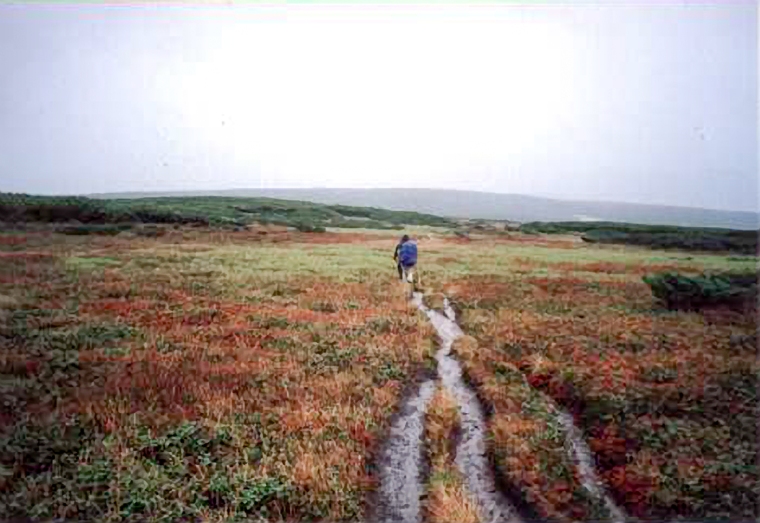
In this way, we crossed the high alpine meadows of the Taisetsuzan massif, following a waterlogged trail that made a kanji alphabet of lines and squiggles across the fog shrouded mountain slopes and ridges. At some point we must have passed unseen the turn-off for the cabin, our previous night’s destination. But time was pressing, and no one felt the desire to sidetrack for scenery.
After the first half-dozen stumbles, I stopped counting face- and ass-plants. With the trail as flooded as this on even ground, I wondered, what waited for us on the descent, with the wind pushing us down-slope? My boots, so warm and dry in the tent that morning, had turned to mud.
Until, finally, in a copse of skeletal trees at the edge of a silent and still alpine lake, we started our descent, first through scrub pine and then into the tree line and the sa-sa which followed us down to the valley.
Water, on the ground, in our boots, or in the air, had become an inescapable fact of our sawanobori trip. Once again we found ourselves following a river. Rapids and mini-waterfalls served as stepping-stones into this steeper second gorge. But the wind dropped at the tree line and the rain slackened as the afternoon progressed, and the hiking got easier as the sky darkened and we dropped deeper into the dreary gorge. For the third straight day anxiety drove us on, barely stopping for breath or water, or to treat the blisters that popped on our battered feet.
Trail markers counted down the distance to the rotenburo, outdoor hot spring, which marked the end of our trip: 2 km, 1.9 km, 1.5 km, 1 km. And then the signs stopped. The rocks above and below the stream blended into a smear of dark greens and shadow.
Dusk set on the mountain, and the gorge turned translucent. Trees and rock outcrops glowed milky in the dark. Once again a steady rain, condensation that hung in curtains from the spindly trees, and the splashing mountain stream, chilled and soaked us. And then, just as it seemed like we would need to make yet another makeshift camp, we crested a narrow line of boulders and emerged at a log bridge and the churning river that flowed past the rotenburo.
An hour later we sat on slime-covered rocks in the hot spring’s turgid, greasy waters, breathing in an incense of sulphur and algae. In the dark, surrounded by the shadowy bulk of Daisetsuzan, it was easy to imagine the primordial sludge in which we steeped as the product of Izanagi’s and Izanami’s love. What the cold, fast-running river took from us, the strength of our muscles and the will of our spirits, this hot spring now gave back. The river we had climbed and the pool in which we now soaked had their sources in the same mountain, and we floated in that fecund pool, afloat in the perfect closure to our trip.
(Originally published as “Water and High Places” in Travelmag, 2001. Photos by Hashi. R.I.P.)